On February 15, 2026, the bulk carrier, Grumant (IMO: 9385879) was pictured at the occupied Ukrainian Port of Feodosia on the Crimean peninsula. Satellite imagery suggests it had already been there for several days. It appeared to stock up on grain before departing on a two-month-long journey eventually docking at the Port of Benghazi in Libya on April 18.
While there have been previous reports of grain shipments from occupied Ukraine arriving in Libya, this is only the second time a Russian ship has been observed delivering what the Ukrainian government describes as “stolen” grain to the country. The previous case involved the Damas Wave which travelled in January of last year to the port of Misrata which is under the control of the UN-recognised Government of National Unity (GNU). In addition to satellite imagery, Bellingcat deployed a new technique that analysed Grumant’s heading data which was contained in AIS information provided by Lloyd’s List Intelligence, to help confirm Grumant’s presence in Feodosia.
Bellingcat has been tracking smuggled Ukrainian grain shipments as they find new markets, five of the ships we previously identified have since been sanctioned by the EU while another was sanctioned by the US Department of Treasury.
Bosphorus Strait
Grumant transits the Bosphorus Strait in the middle of the night.
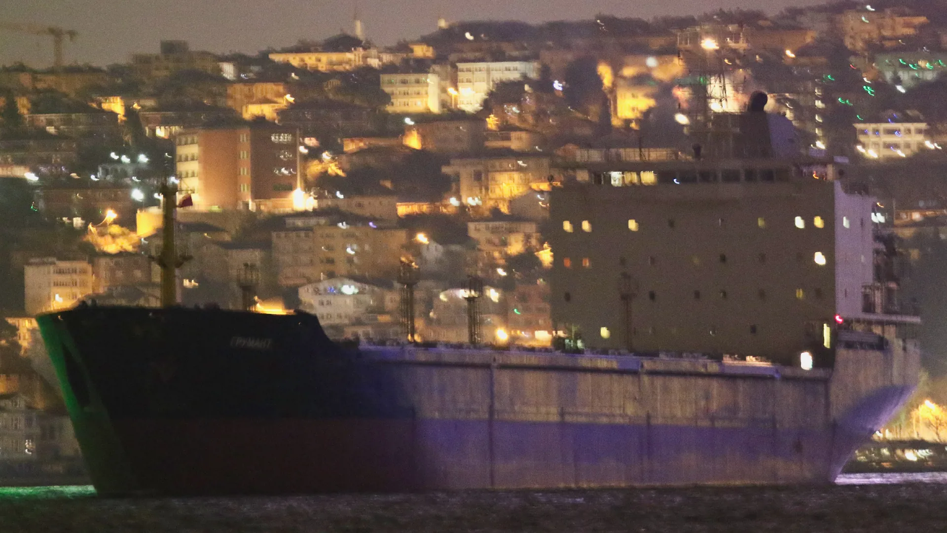
Credit: Yörük Işık.
Black Sea
Grumant enters a region of the Black Sea known for GNSS interference, meaning that Grumant’s publicly reported Automated Identification System (AIS) position is unreliable.
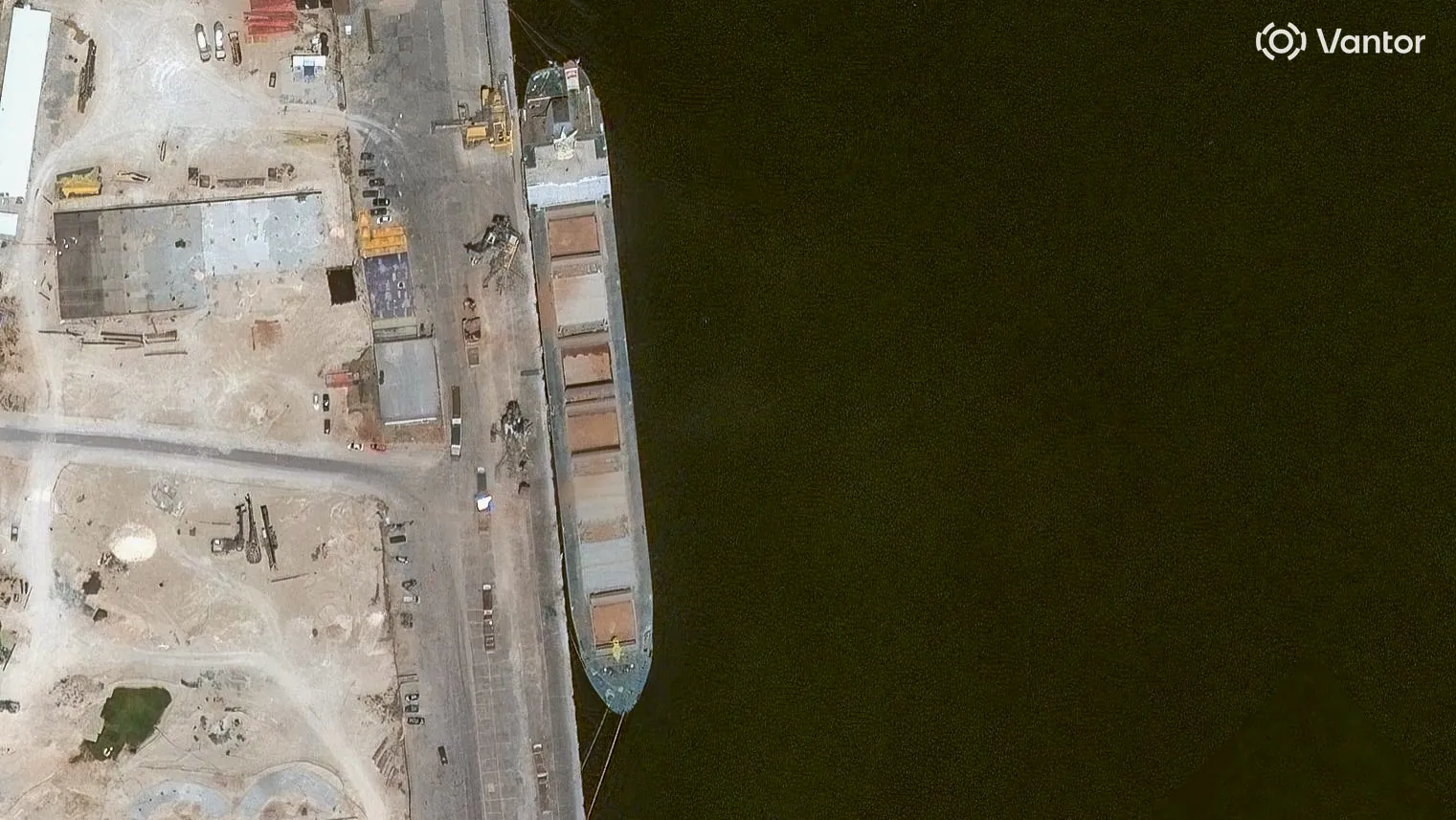
Port of Feodosia
On February 15, a high resolution satellite image confirms the ship is docked at the port of Feodosia at berth No. 1 that is used for bulk and metal cargo. Matching features visible include Grumant’s grey decking, its seven hatches and bright yellow front mast. What appears to be leftover grain can be seen under the two port crates, immediately next to the ship.
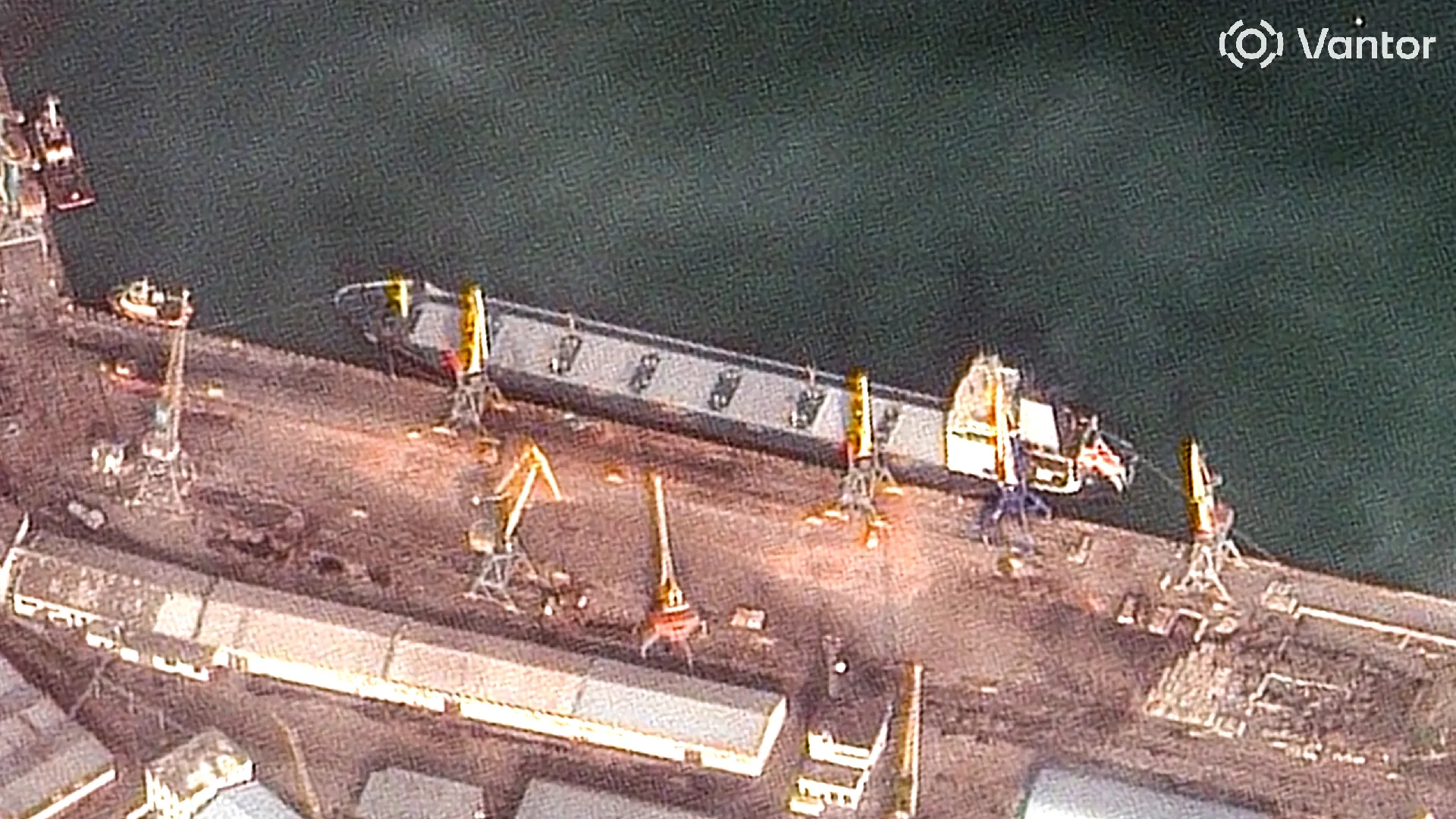
Credit: Satellite image ©2026 Vantor.
Black Sea
Grumant exits the area of signal interference, meaning that its reported position on ship tracking services is now reliable again. Its AIS messages indicate it is travelling towards the Bosphorus.
Bosphorus Strait
Grumant transits the Bosphorus Strait towards the Sea of Marmara. Judging by the draft, with no visible red paint on its hull, the ship appears to be fully laden.
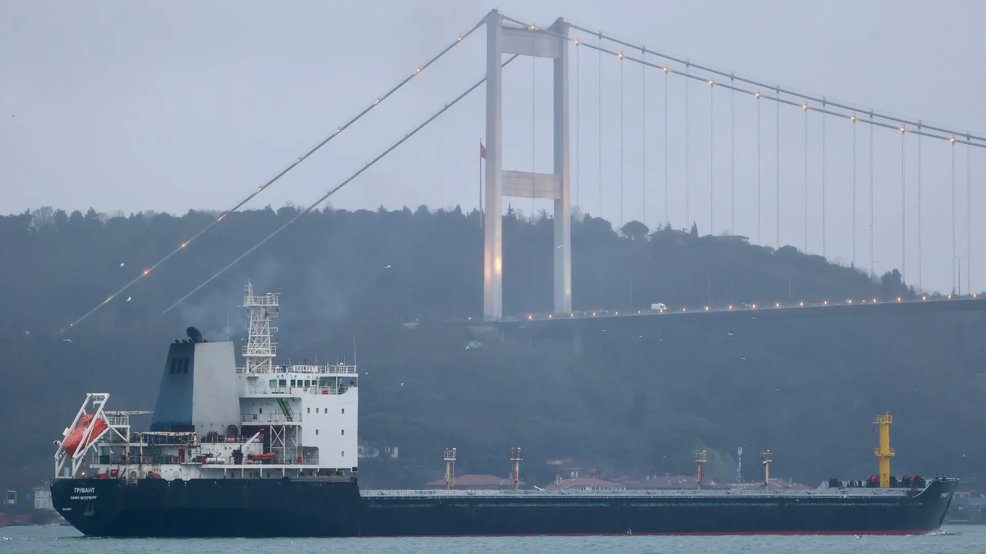
Credit: Yörük Işık.
Izmir Anchorage
Grumant arrives in Izmir, Turkey on February 23 and anchors off the coast until March 13.
Over the course of three weeks, Grumant never enters the Port of Izmir. It is not known if it was denied entry. Bellingcat asked the port operators but did not receive a response before publication.
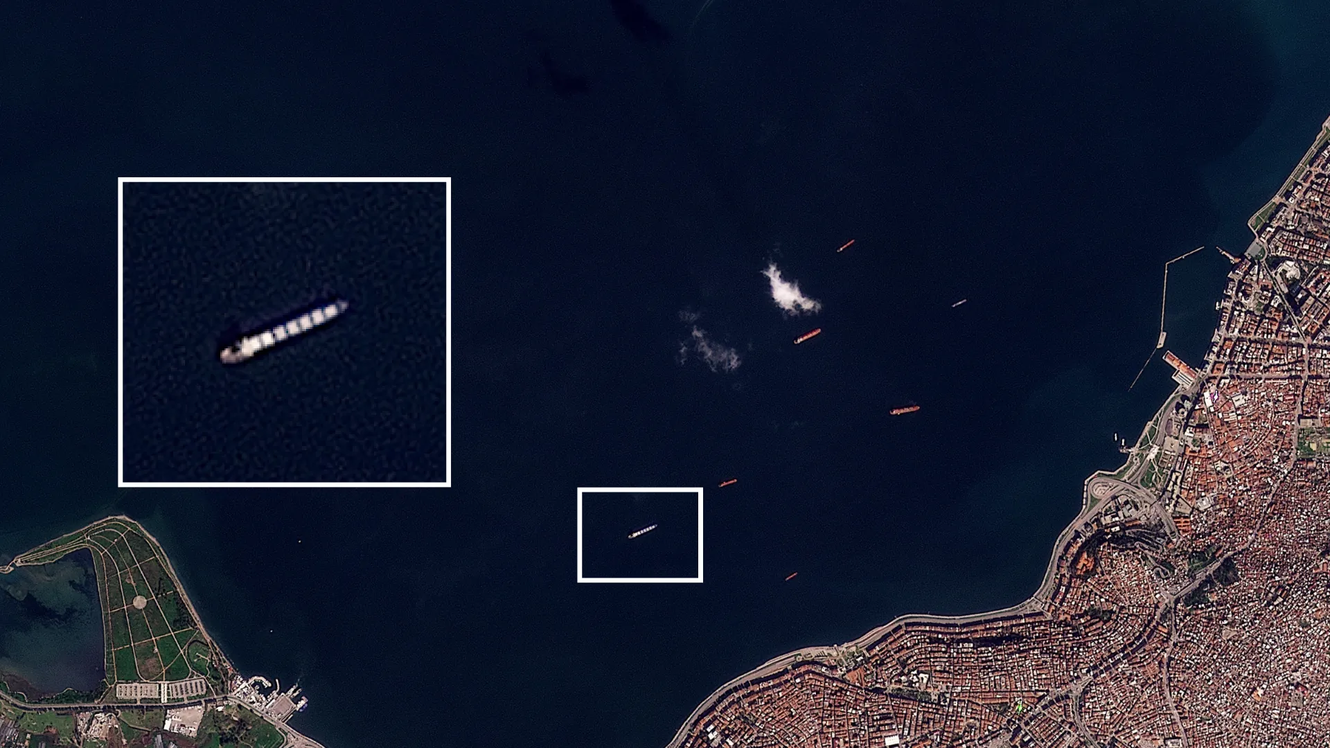
Credit: Planet Labs PBC.
Aliağa
Grumant then loiters off the coast of Aliağa, about 50 km from Izmir. It stays here until March 16, never entering the port. It again is not known if it was denied entry. Bellingcat asked the port operators but did not receive a response before publication.
Near Benghazi
Grumant arrives in Libyan waters and stays off the coast of Benghazi until April 1.
Libyan Waters
Grumant briefly leaves the coast of Benghazi, but returns a few days later.
Benghazi
Grumant leaves the anchorage on April 18 and docks at the port of Benghazi where it unloads the grain. The ship was captured in a Vantor satellite image on April 20.
It leaves port on April 23, and heads back towards the Bosphorus.
Credit: Satellite image ©2026 Vantor.
Bosphorus Strait
After spending a few days off the coast of Tuzla, Grumant transits the Bosphorus towards the Black Sea.

Credit: Yörük Işık.
Lloyd’s List Intelligence has previously reported on the expansion of Russia’s grain smuggling operations, beyond the occupied port of Sevastopol to include Feodosia port.
According to the Ukrainian activism, journalism and hacker group, Kiborg News, Grumant used deceptive shipping practices to deliver grain to Latakia, Syria in 2024. The report included several of Grumant’s shipping manifests, which showed it had repeatedly exported grain from Occupied Crimea to Syria.
Heading Data Helps Locate Grumant
It is standard maritime practice that ships broadcast Automatic Identification System (AIS) messages which include a ship’s position, heading, and draught (among other information).
Because of longstanding Global Navigation Satellite System (GNSS) interference in parts of the Black Sea, the position data transmitted by an affected ship’s AIS system is often unreliable.
Between February 7 and February 19, 2026, data from Lloyd’s List Intelligence shows the Grumant transmitted 29 AIS messages, with unreliable positions in the vicinity of Feodosia. We know these positions are unreliable as they are erratic and some of them report the ship as being positioned on land.

However, according to the IMO, the heading data transmitted by a ship’s AIS system must come from an onboard compass. A compass is unaffected by GNSS interference, meaning it is a more reliable source of information in these conditions.
Over the same dates, all 29 AIS messages reported the ship’s heading as 267 degrees or 268 degrees. The Port of Feodosia has a heading of 267.5 degrees. The close agreement between the ship’s heading and port heading strongly suggests that Grumant was moored at the port between February 7 and February 19, 2026.
We conducted an extra check of the heading data by reviewing satellite imagery available of berth 1 at Feodosia Port, which suggests that the same vessel was present on several days between February 6 and February 18. Imagery on Feb. 6 shows the port was empty in the morning and occupied in the afternoon. Grumant exited the area of GNSS interference on February 21, and berth 1 at the port was captured on satellite image on February 22 and appeared empty. The low resolution satellite imagery is only used as an additional check to see if a vessel is at the berth.


Bellingcat checked all vessels transmitting AIS in the vicinity of Feodosia Port and found that Grumant was the only one that consistently transmitted a heading matching the Port of Feodosia over the period of interest.
We shared our research with Charlie Brown, a former US Naval Officer and Senior Advisor at United Against Nuclear Iran where he focuses on maritime sanctions enforcement and the tracking of illicit shipping. Brown told Bellingcat that while satellite imagery of vessels remained key for identification, when looking for reliable data in a spoofing environment it made sense to look at the various elements of AIS data to try and find some accurate information, despite GNSS spoofing.
“It’s quite standard for the independent gyro compass to be providing the heading […] I think the majority would not [be subject to spoofing] so it’s a good methodology to parse out the particular data and then make some inferences from that.”
“It’s neat to think of what can be derived from data that would otherwise be dirty or wrong. So there’s still some elements of use in there.”
He added that in theory there are probably some compasses that are subject to spoofing as well.
He told Bellingcat that it was fair to say the heading data of the Grumant supported identification, but stressed the need to cross-reference with other data sources.
While in this instance it has been possible to use AIS data to help verify the location of Grumant, it is relatively unusual to have access to this information.
Ships that call to the occupied territories frequently disable their AIS transponders to do so.
This activity, known as “dark port calls”, is a common tactic for those engaging in illicit or sanctioned trades.
Grumant does not transmit AIS messages from February 8 to 11, but this is the longest gap in data (see diagram above), with intermittent messages coming through after that point.
It is unclear why Grumant continued to transmit AIS during the period it was loading in Feodosia.
A review of Lloyd’s List Intelligence data from January 2025 shows that on a previous voyage to the Black Sea the Grumant operated “dark” for 59 days.
Visual Identification
On February 15, 2026, high resolution imagery showed Grumant docked in the Port of Feodosia. We compared it with other recent images of Grumant to confirm the match.
The ship in the satellite image has a grey-coloured deck, which is uncommon enough for it to stand out. Many bulk carriers have cranes (including the ships we previously covered such as Krasnodar, Zafar and Zaid), Grumant does not have any. It also has seven hatches (openings for the grain) and a bright yellow front mast that matches the mast of Grumant (see the image of it transiting the Bosphorus). We can match the Grumant in the Feodosia image, not only to pictures of the Grumant shot from the ground, but also to the satellite image from Benghazi.
The length and breadth of the ship also matches that of the Grumant; 180 metres by 22.90 metres.


Libya’s Relationship with Russia and Ukraine
Libya has complicated internal dynamics with essentially two administrations in charge of different parts of the country – the Government of National Unity (GNU) in the west and the Libyan National Army (LNA) in the east.
In recent years, Russia has backed the LNA’s General Khalifa Haftar, based out of Benghazi, in the east of the country. But Jalel Harchaoui, a political scientist specialising in Libya with the Royal United Services Institute (RUSI), stressed that the two sides of this conflict, the LNA and the UN-recognised GNU, are not currently fighting. Instead they are in a flawed, multi-year truce.
Therefore, the east-west divide isn’t as clear-cut as during the civil war. While all shipments going to Benghazi and Tobruk are overseen by the LNA, not all shipments going to the city of Misrata (which is run by the GNU) are meant for the GNU-dominated part of the country.
Harchaoui told Bellingcat: “the Tripoli government is in some regards pro-Ukraine, but if there’s business that can be done with Russia through the very opaque port of Misrata and all the right people get paid, the business is going to take place.”
That observation is potentially significant given at least one previously tracked vessel that went from occupied Ukraine to Libya docked in Misrata.
This was not the case of the Grumant, however, which arrived in an LNA-controlled part of the country. It is not known from open sources alone if the authorities in Libya or at the port in Benghazi knew the grain carried by Grumant had come from occupied Ukraine.
Bellingcat contacted the Benghazi-based LNA government and representatives of the Tripoli-based GNU government via the Libyan Embassy in The Netherlands. We also contacted the Port of Benghazi, Port of Imzir in Turkey as well as the Ukrainian and Russian authorities. Representatives of the LNA did not respond to requests for comment before publication, nor did the Port of Benghazi or Port of Izmir. The Libyan Embassy in The Netherlands replied to Bellingcat after publication, stating that Benghazi and eastern Libya are not under the authority or administrative control of the Government of National Unity and therefore they are not currently in a position to comment on Bellingcat’s findings.
Ukraine Continues to Pursue the “Shadow Grain Fleet”
“The port of Feodosia, located in the temporarily occupied Autonomous Republic of Crimea, is not under Ukrainian control, and any commercial activity conducted there is illegal,” the Ministry for Development of Communities and Territories of Ukraine and the Ministry of Foreign Affairs of Ukraine told Bellingcat in a joint response.
They told us the loading of grain exported from the temporarily occupied territories is an illegal act and Russia was using ports as logistics centers to export stolen Ukrainian agricultural products.
“The expansion of such routes to third countries, in particular to North Africa, demonstrates Russia’s ongoing efforts to circumvent international sanctions and monetize resources stolen from the occupied Ukrainian territories.”
The Ukrainian Ministry of Foreign Affairs sent information about Grumant’s (IMO: 9385879) “illegal activities” to the diplomatic missions in Great Britain, the Republic of Turkey and the Republic of Tunisia over the course of March to May this year, the ministries told Bellingcat.
Ukraine is continuing to pursue legal action against Russia’s “shadow grain fleet” they told us. For instance, earlier this month a Swedish court approved the transfer of the Russian “shadow grain fleet” vessel CAFFA to Ukraine for investigation after it was arrested in Swedish waters.
This case has set a new precedent, going beyond sanction and fines previously handed out to such vessels, and allowing for the detention and confiscation of a shadow fleet vessel in European jurisdictions, the ministries said.
According to Russian court documents Grumant’s previous owner Murmansk Shipping Company was dissolved and “Decision/Reshenie” LLC were listed as the International Safety Manager and operator of Grumant. Decision/Reshenie were also listed as the operator of Grumant in another court document, from an unrelated case.
Bellingcat attempted to contact Decision/Reshenie to ask about Grumant’s grain shipment from Feodisia Port to Benghazi Port, but they had not responded at time of publication.
Youri van der Weide, Galen Reich, Yörük Işık and Bridget Diakun contributed to this report.
Cover image: Planet Lab image shows Grumant anchored off Izmir, Turkey on February 27. Credit: Planet Labs PBC.
Bellingcat is a non-profit and the ability to carry out our work is dependent on the kind support of individual donors. If you would like to support our work, you can do so here. You can also subscribe to our Patreon channel here. Subscribe to our Newsletter and follow us on Bluesky here, Instagram here, Reddit here and YouTube here.
The post Heading Off: New Technique Helps Track Grain Smuggling Expansion to Libya appeared first on bellingcat.